Counter-UAS Site Defence

Plan the drone defence — before the raid.

OAK Sentry is a base-defence planner's tool: lay sensor and effector posts around criticality-weighted assets, see the terrain line-of-sight-masked detection and effective-kill coverage over the site, fly a mixed-threat Monte-Carlo raid against the posts' effector channels, read the per-threat-axis PASS / THIN / GAP table, and get an A–F defence grade with a one-click laydown optimizer.

UNCLASSIFIED · representational // defensive planning only — no weapons-employment or exploit content
A–F
defence-posture grade + scorecard
Terrain
line-of-sight coverage shadows
Groups 1–5
DoD UAS group threat models
100%
offline · no GPU · air-gap-friendly
The defence-planning layer

The truth flat-earth range rings hide

OAK Sentry extends the EW SUITE's single-site C-UAS physics (cuas_model, cuas_engage) and terrain line-of-sight (terrain_io) from one site into the spatial, multi-post base-defence problem — and surfaces the two things that decide the fight: terrain shadows and autonomous threats.

Terrain LOS masking

Detection and engagement are line-of-sight masked with earth curvature and 4/3 refraction: a ridge casts a radar shadow low, slow drones exploit (~21–32% coverage lost) while high flyers clear it — the coverage a range-ring plot falsely claims.

Real terrain, named sites

Drop the laydown onto real 30 m SRTM elevation for named Canadian sites (CFB Valcartier, Esquimalt, Comox) — actual ridgelines shape the coverage and effective-kill grids, so the terrain-shadow dead zones are the real ground, not a notional relief.

Soft-kill vs autonomous

RF/GNSS jamming defeats COTS drones but not autonomous / INS threats (Shahed-class). The planner shows every Group-3 threat axis as a GAP — seen but with no effective stop — until kinetic depth is added.

Threat-axis gap analysis

For each approach × UAS group: first-detection range, effective engagement depth, kill probability, warning time — and a colour-coded PASS / THIN / GAP verdict.

Monte-Carlo raid

A geometric raid flies a mixed threat in along the axes and fights it with the posts' effector channels — kill / leak / asset-damage, with saturation of limited jam and kinetic channels.

Defence grade & optimizer

A weighted A–F grade over coverage, redundancy, axis posture, raid survival and engagement depth — and a one-click laydown optimizer that answers autonomous threats with kinetic depth, not another jammer.

Built on the core

Sovereign Canadian IP, ITAR-free, pure-software (no GPU). Reuses the fielded EW SUITE C-UAS engine and terrain library. Defensive planning only.
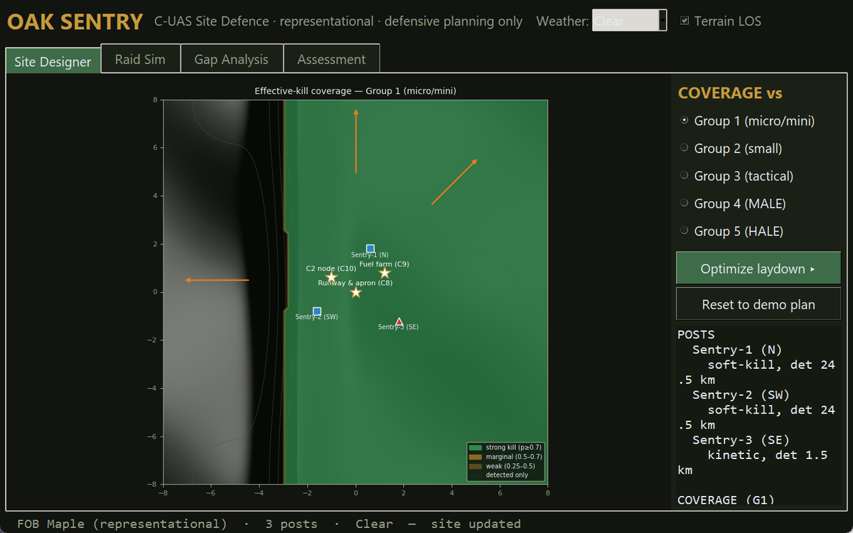
C-UAS Site Defence Console

The laydown, the coverage and the terrain shadow — one screen

  • Site Designer: posts around criticality-weighted assets over a shaded-relief map with a Terrain-LOS toggle
  • Effective-kill coverage per UAS group and weather — where you can actually stop the threat, not just detect it
  • Raid Sim: mixed-threat tracks, kill / leak / asset-damage under channel saturation
  • Gap Analysis: colour-coded per-axis × group PASS / THIN / GAP with detect range, kill p and warning time
  • Assessment: the A–F grade with a weighted scorecard, and a one-click laydown optimizer
OAK Sentry — C-UAS Site Defence Console: terrain-masked coverage with a western radar shadow
Built on the core

Sovereign, unclassified, representational

OAK Sentry is first-principles C-UAS planning physics on a notional site — no operational laydown, no weapons-employment or exploit content. It reuses the EW SUITE's counter-UAS engine and terrain library, carved into its own product tree.

Sovereign Canadian IP Terrain LOS maskingSoft-kill vs autonomous Per-axis PASS / GAPMonte-Carlo raid A–F defence gradeDefensive planning only

See your site's drone defence

Bring a site and a threat picture — or use the built-in FOB — and we'll grade the laydown with you.

Request a demo
Precision engineering for defence, aerospace & space — Kanata, Ontario, Canada